Distance: Approx 10 km. Elevation 153 m. Difficulty: medium.

For this West Sussex walk at Graffham, you’ll need Ordnance Survey Explorer OL 10 and a sense of adventure. This is a fabulous walk but it’s quite easy to get lost in places. The good news is that it is also reasonably easy to find yourself again. In winter, it can get very wet underfoot but in early summer it’s home to a fabulous rhododendron alley! And although we followed a pre-planned route, this is such a great little corner of Sussex you might just want to explore without a destination or purpose in mind.

The 10 km route
From Petworth head south on the A285. Once you’ve passed the Beam Pump bridge, travel a couple more miles and then turn right. It’s the first turning to the right. After two or three, kilometres you’ll find a car park at Lavington Common on your right (What3Words:level.enjoys.fortress).

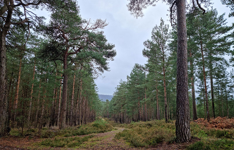
Lavington Common is an area of heathland with heather, gorse, bracken and pine trees and marks the start of this West Sussex walk at Graffham. From the car park, you take the Serpent Trail east and go across the common towards Duncton Common and into Merlin’s Wood (although it’s not named Merlin’s Wood on the map). After a couple of kilometres, you’ll see a clearing in the field in front of you and you turn hard left leaving the Serpent Trail behind you and following a bridlepath instead (blue markings).

This is a truly delightful part of Merlin’s Wood with rhododendrons and vast pines and the occasional glimpses of fantastic views across the countryside to the north. Keep going straight along this path. With the rhododendrons to your left, the pines eventually slope away to your right as the path also curves round to the right and brings you down to a little lane. Turn left and then right here and pick up a footpath between open fields. It’s pretty much a ditch for the first part, so it can get pretty wet but keep going and eventually you’re on drier ground.

My mistake!
After a couple of kilometres, you will come to a lovely, converted barn to your right with floor to ceiling windows and original, narrow ventilation windows in the stone.

It’s here I made a mistake. At this point, you are at the very top of the map and for just a millimetre or two the route you want goes on to Ordnance Explorer 133. I didn’t take that map with me and so missed the fact that in those two missing millimetres I should have taken a sharp left south to Fitzlea Farm and Fitzlea Wood. Instead, we walked along the very muddy old, dismantled railway and came out at Hurlands Farm at Selham.
Selham
Selham is small but was mentioned in the Domesday book and is just south of a mound which was once the site of the 13th century Lodsworth Castle. Selham is also home to an 11th century church and 12th century Priory (now a private house) and Selham House which stands in some 15 acres of landscaped gardens and grounds and was previously owned by both the Cowdray family of Midhurst and the Maharajah of Bahawalpur. Selham is also home to The Three Moles and if you’ve come this way by mistake, this is the place to stop for refreshments.

The Three Moles
A fabulous country pub, The Three Moles was built by William Townley Mitford and opened in 1872. It originally served the railway opposite (which closed in 1955). The name comes from the three moles on the Mitford family crest and the pub has won a number of CAMRA awards including West Sussex Pub of the Year on at least 4 occasions as well as coming a national runner up.

If you’ve walked down the old railway bridlepath, turn left and you’ll see the pub shortly (if you’ve gone the Fitzlea wood way, you won’t pass the pub). Once you have refuelled, you carry on south from the pub (left as you come out of the door) and when you get to Selham House you turn left. Then as you meet the tree line you will turn right into the woods. If you had stuck to the original route and not made my mistake, you would have arrived at this point a little sooner (from the turning now on your left) but then you would have missed The Three Moles.
Graffham Common
You’re now into Graffham Common and it is absolutely enchanting, even on a wet, rainy day. Graffham Common is a 94-acre nature reserve owned and managed by the Sussex Wildlife Trust. This area was previously almost entirely pine plantation and rhododendron, but the Sussex Wildlife Trust has been gradually clearing it and restoring it to wooded heath.

Although originally we planned to walk on to Selham Common, having been on our fairly extensive diversion we headed instead for Gallows Hill in the centre of the woods. They say this is where people were hanged so that they’d be visible from miles around and they also say you can see Petworth House. We couldn’t but it’s gorgeous here nonetheless and a great place for a pause. Just visible through the trees is the massive and colonial-style Millborough House (Millburgh Hall) which now seems to be private housing.
Along the ridge here, you can apparently find Bronze Age burial mounds and the area also has a few old sand and ironstone quarries that supplied iron for the Weald iron industry. More recently, the area was used for training Canadian soldiers for the D-Day landings. But from a modern-day walkers point of view, it’s just an absolutely delightful area of forest.
It’s quite easy to get lost here as there are lots of paths which are not marked on the map but all roads do feel like they lead to Rome. In the end, we followed a couple of dog walkers who seemed to know where they were going!
The Serpent Trail
When you’ve meandered enough here, you want to head to the Serpent Trail once more. It cuts through the middle and you want to head east along it until you wiggle your way to a lane. Turn right here onto the lane. You have a choice now: follow the road back to the car park or turn right at the first little junction and continue on the Serpent Trail. Both routes will bring you back to the car.

The latter route cuts through Lavington Plantation and runs more or less parallel to the road anyway … it’s just a much nicer, if slightly soggier way to travel. Owned by the National Trust, this area was open heathland until 1958 when it was densely planted with pine. The National Trust have been gradually returning it to open heathland since 2000.
Although there aren’t many car parks in the area, there are quite a few places you can park and if you don’t want to walk as far as 10 km, I wholeheartedly recommend you bring a picnic and some binoculars for the wildlife and just spend some time here coddiwompling about! It’s a lovely part of the world and you’re finished, don’t forget to stop in Midhurst to explore the antique markets and coffee shops.
If you’ve enjoyed this West Sussex walk at Graffham, you may also like:


